Ancient Mysteries
An ancient map was found in renovations of a palace in Turkey.
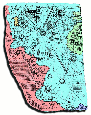
During renovations of the old Imperial Palace in what is now Istanbul (formerly Constantinople), a painted, parchment map was found, dated in the month of Muharrem, in the Moslem year 919 (A.D. 1513), and signed by an admiral of the Turkish navy, Piri Ibn Haji Memmed, known as Piri Re'is.
Thought to be one of the earliest "world maps" to show the Americas, the map was originally used to bolster Turkish national pride. Early scholars suggested that it showed accurate latitudes of the South American and African coastlines - only 21 years after the voyages of Columbus! (And remember, Columbus did NOT discover North America - only the Caribbean!) Writing in Piri Re'is own hand described how he had made the map from a collection of ancient maps, supplemented by charts that were drawn by Columbus himself. This suggests that these ancient maps were available to Columbus and could have been the basis of his expedition.
A copy of the map was presented to a diplomat in the U.S. government, where it remained a curious artifact for years. The true mysteries of of this map were eventually discovered by professor Charles H. Hapgood and revealed to the scientific community in his book, Maps of the Ancient Sea Kings. During scrutiny of the map, Hapgood discovered a partial charting of Antarctica, made during a period when the coast was free of ice. This coastal structure, now covered again by ice, was subsequently verified by satellite radar scanning. Ice core samples of the coastline have fixed the last ice-free period to between 11,000 B.C. and 4,000 B.C.
Hapgood has proved that the Piri Re'is map is plotted out in plane geometry, containing latitudes and longitudes at right angles in a traditional "grid"; yet it is obviously copied from an earlier map that was projected
(See similar map on right, based on spherical projection and used for air flights originating in Cairo to determine distances and fuel consumption. This map was generated using sherical trigonometry - a science unknown to scholars until its discovery by the mathematician Hipparcus).
Other Unusual Findings:
Piri Re'is own commentary indicates that some of his source maps were from the time of Alexander the Great (332 B.C.).
The Piri Re'is map is often exhibited in cases seeking to prove that civilization was once advanced and that, through some unknown event or events, we are only now gaining any understanding of this mysterious cultural decline.
The earliest known civilization, the Sumerians in Mesopotamia, appear out of nowhere around 4,000 B.C. but have no nautical or maritime cultural heritage. They do, however, speak reverently of ancestral people who were like the "gods" and were known as the nefilim. But that is yet another story.
The Piri Re'is Map of 1513
The copy of the map gathered dust for years until a professor
with an interest in maps took a closer look.
His findings shocked the scientific world with a challenge to our history and culture.
 Background:
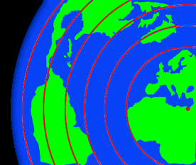 Our historical understanding of navigation includes a period of time before which it was impossible to determine a ships latitude (North to South position) in the Southern Hemisphere. This was because the known method involved sighting the angle of the only fixed star - the North Star - which cannot be seen in the Southern Hemisphere because of the curviture of the Earth. Despite this handicap, these maps show amazing details and acurate latitude placement of many known islands along the southern most coastlines of Antarctica! But this paradox of history was made even more astounding.
using spherical trigonometry! Not only did the early map makers know that the Earth was round, but they had knowledge of its true circumference to within 50 miles!

Other history related articles on this site:
.
.
.
.
.
.
.
.
.
.
.
.
If you have a suggestion or history related article to submit, send it to:
Editor/viewzone.com
myristicin@hotmail.com