|
The evidence proving that the poles where in different positions during the Pleistocene era is quite impressive, and this explains why Hapgood's theory was approved by scientists such as Einstein and K.F. Mather. But his theory meets with so many difficulties that it becomes highly controversial. Above all, it seems to conflict with widely accepted theories, such as the drift of the continents. Hapgood, while credited with correctly plotting the positions of past polar coordinates, was forced to adhere to a much slower transition of the poles, accepting the paradigm of continental drift and plate tectonics to maintain the support of the scientific community.
Ironically, one of the most recent objections to Hapgood's theory is the rapidity of climate changes that occurred in the Pleistocene period. According to Hapgood's revised theory, it took the North Pole at least two thousand years to move from its previous position to the present. The evidence we now have, however, definitely points to much faster climatic changes.
It was Hapgood himself who first underscored the enormous amount of evidence proving the high speed at which the shift of the poles appears to have happened; speed which the mechanism of continental drift is unable to explain.
The only way to completely and coherently explain what took place at the end of Pleistocene era appears to be that of admitting the possibility of a shift of the poles of the same magnitude Hapgood hypothesizes, but in a much shorter time: not more than a few days! This possibility is openly refused, only because no convincing explanation has been forwarded so far. It would, however, support the abrupt disaster that befell Atlantis -- if it is under Antarctica's polar ice cap. With no hard data to explain this extremely abrupt disturbance in geography, Hapgood continued aligned with the theory of a gradual shift. In the forward to a book on the subject, Hapgood wrote:
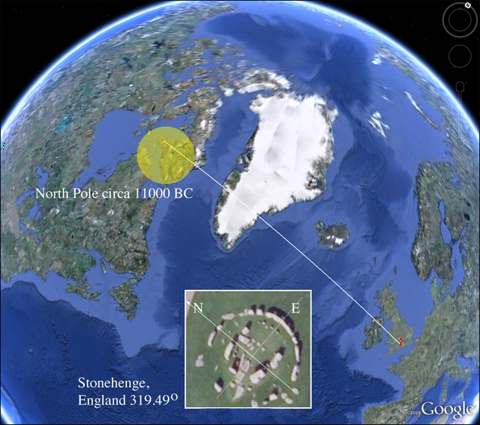
New Evidence -- Enter STONEHENGE!
Thomas O. Mills has written extensively on the Hopi culture -- the oldest Native American tribe. The Hopi are extremely private people who do not usually share their cultural secrets with outsiders. Mills has been fortunate to live with the Hopi and has come to appreciate their depth of knowledge of nature. He is particularly fascinated by their understanding of celestial alignments.
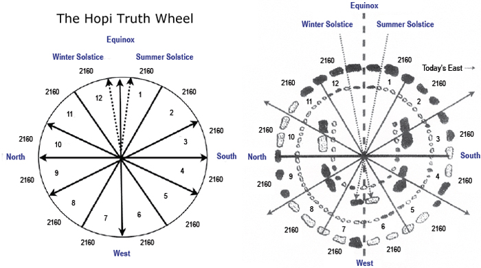
In his book, Stonehenge: If This Were East, Mills shows what he calls the Hopi Truth Wheel. This is a compass like circle that, when aligned to the North Pole, reveals the direction of the Sun and certain significant stars for the Equinox and Summer and Winter Solstice. Mills examined the possibility that Stonehenge might have utilized this same Truth Wheel in its construction. His results were quite remarkable.
The current alignment of Stonehenge makes no sense as to important alignments thought to be useful to the ancients who made it. This is why there has been great controversy and argument over the original purpose of the placement of the stones. But when Mills placed his "wheel of truth" over Stonehenge he immediately noticed that the stones were in perfect alignment. There was only one problem -- they didn't align with the North Pole.
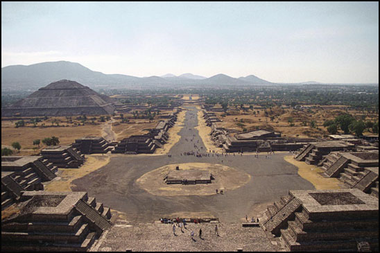
The Avenue of the Dead
Another anomaly that has perplexed archaeologists has to do with the ancient pyramid site called Teotihuacan, also known as The Avenue of the Dead. It consists of several step pyramids situated along a straight corridor. But the corridor (or avenue) doesn't align with anything. It is in the northern direction but not exactly North. For a civilization that was known for its precision and calulating, this seems very odd.
Teotihuacan is an enormous archaeological site in the Basin of Mexico, containing some of the largest pyramidal structures built in the pre-Columbian Americas. Apart from the pyramidal structures, Teotihuacan is also known for its large residential complexes, the Avenue of the Dead, and numerous colorful, well-preserved murals.
The early history of Teotihuacan is quite mysterious, and the origin of its founders is debated. For many years, archaeologists believed it was built by the Toltec. This belief was based on colonial period texts, such as the Florentine Codex, which attributed the site to the Toltecs. However, the Nahuatl word "Toltec" generally means "craftsman of the highest level" and may not always refer to the Toltec civilization centered at Tula, Hidalgo. Since Toltec civilization flourished centuries after Teotihuacan, the people could not have been the city's founders.
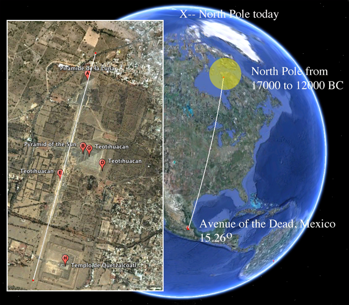
Using google earth again, we extended a line along the "avenue" and found that it did align with the North Pole as it existed 12,000 to 17,000 years ago.
Does this suggest that the site is much older than we currently estimate? I believe it does.
The geographical layout of Teotihuacan is aligned to 15.26º east of North. One theory says this is due to the fact that the sun rose at that same angle during the same summer day each year. Settlers used the alignment to calibrate their sense of time or as a marker for planting crops or performing certain rituals. Another theory is that there are numerous ancient sites in Mesoamerica that seem to be oriented with the tallest mountain in their given area. But perhaps the site was constructed over the ruins of a much older, ancient city.
Adams calendar -- how old?
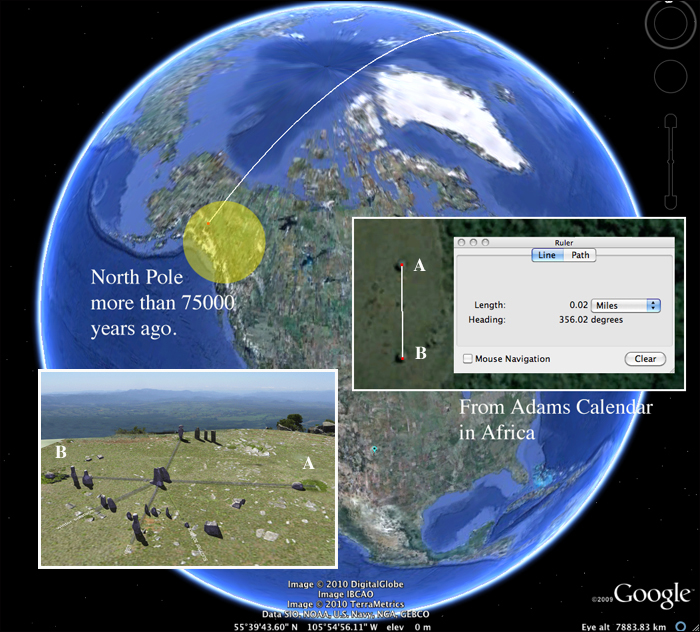
Viewzone recently ran a story on an alleged 200,000 year old settlement that was recently discovered in South Africa (see Adam's Calendar). Aside from thousands of foundations and walled streets and paths, an astronomical stone calendar was found, almost completely intact, on the top of a mountain just above the old settlement.
The positioning of the stones is quite amazing and shows alignment with Mill's "wheel of truth." There are stoned to calculate the equinox and solstice. But once again the North and South stones do not align perfectly with the current directions.
Using google earth we extended a line through the South and North stone markers and saw it intersect with the North Pole as it would have been positioned about 75,000 years ago. This is the earliest date for which we have geomagnetic evidence of a magnetic pole. While we can only speculate that even earlier polar positions existed we can use this as evidence that the Adams Calendar site is at least this old.
Comments:
|